11 Reasons the Proposed Berm WILL NOT Protect Bowness Residents from Flood Damages
A study conducted by Dr. Cathy Ryan and a Master’s student at the University of Calgary on Elbow River communities following the 2013 flood (Abboud et al, 2018) confirmed what long time Bowness residents with sumps or wells in their basement have known for years, that the groundwater table and the river are part of one system. Consequently, a flooding river means a rising groundwater surface, resulting in basement flooding by seepage and/or sewer backup as the groundwater finds its way into a combination of basement cracks or seams, homeowner sumps, sanitary and stormwater systems. This direct relationship in elevations is well illustrated in excerpts from presentation given in 2015 by Ken Hugo, of Groundwater Information Technologies, on his work on the Bow River (Figures 1 and 2).

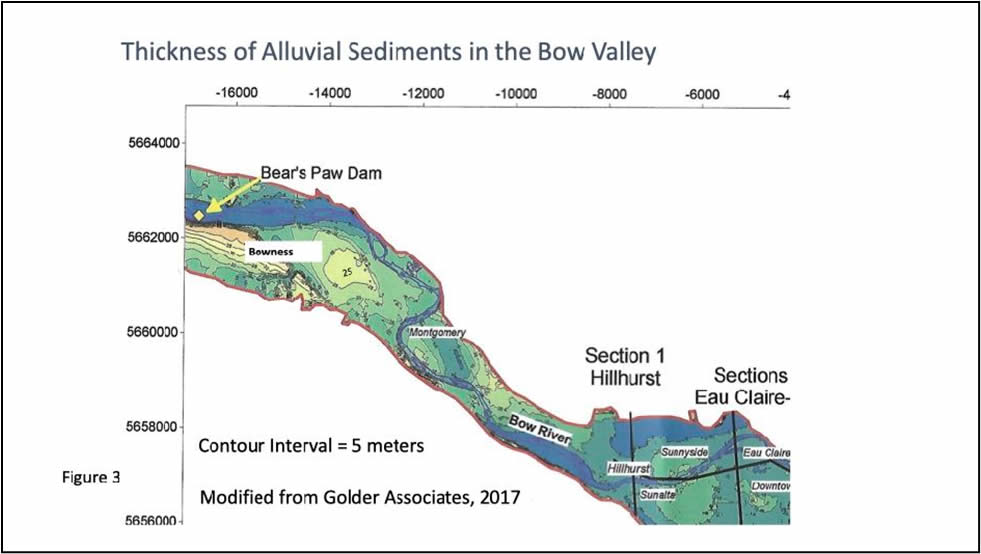
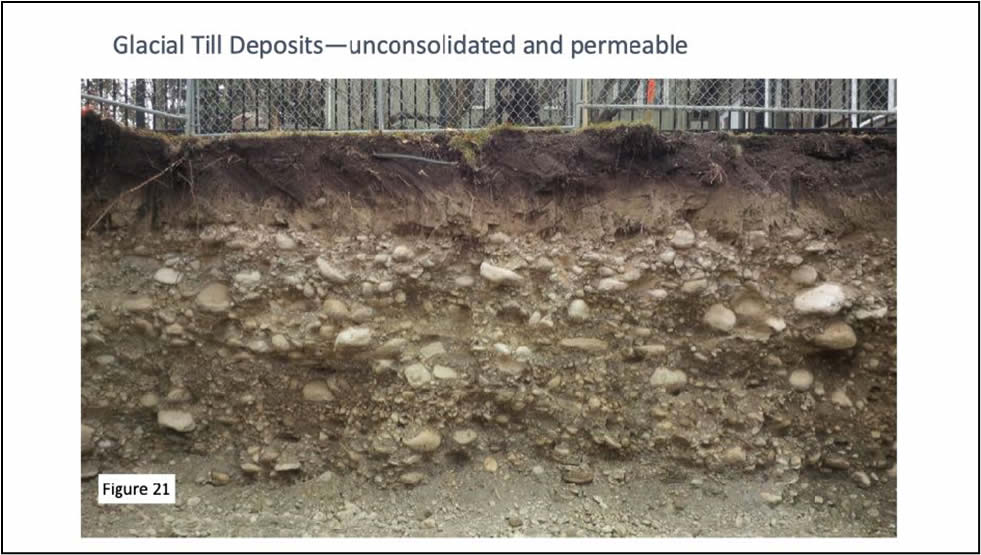
The reason for this rapid response lies in the fact that Bowness, like much of the city of Calgary, is underlain by high permeability alluvial sands and gravels of both glacial and fluvial (river) origin (Figures 3 and 21). Within the valley, there are also broad areas where the unsorted glacial tills (sediments) have been reworked and ‘cleaned up’ by the river, increasing their permeability. Unfortunately, a review of the City of Calgary (“The City”) commissioned report, titled “Hydrogeological Characterization and Groundwater Flow Modelling Report” by Klohn Crippen Berger (“KCB”), 2021 referred to as “the Groundwater Report”, revealed that most of the hydrogeological flow test data was located such that it did not evaluate the highest permeability areas, areas where tills have been reworked by the river following the last glaciation. It is in these very areas, which are the topographically lowest locally, where the flood-affected residents reside. In the view of BRFMs technical committee, this limits the utility of the Groundwater Report in that it presents overly optimistic conclusions with regard to both the speed and degree to which residents will be groundwater flooded even with the Surface Event Barrier (SEB) in place. KCB (2021) has recognized this shortcoming in the data collection and distribution so in their recommendations for future work, on page vi of the Groundwater Report they included:
i) Continue monitoring groundwater levels and water chemistry at select wells within monitoring network. Install pressure transducer/dataloggers in those monitoring wells not instrumented during 2019, which are not dry for significant periods of the year.
ii) Install, develop and hydraulically test (slug and constant-head testing) three monitoring wells, each screened across the alluvial aquifer, one between existing wells MW19-03 and MW19-04, a second between MW19-08 and MW19-09 and a third between MW19-09 and MW19-10.
iii) Compile and analyze this data and use as input to the next design phase. Should the City of Calgary wish to proceed with investigation of a greater level of groundwater mitigation, a more extensive field program is advocated, and is presented in Appendix V of this report.
It should be noted that despite this overly optimistic appraisal of the groundwater problem, widespread subsurface flooding of residents’ basements is still predicted, as the reduction in groundwater elevations with the barrier in place will be insufficient to stop basement flooding (see Figure 4). For example, the Groundwater Report noted in ‘Section 7.2: Conclusions’ that :
“Simulation of the Surface Event Barrier (SEB) indicates that the proposed SEB will not result in higher water tables during flood events and will marginally reduce water table levels in areas close to the river within northwestern and southeastern Bowness.”
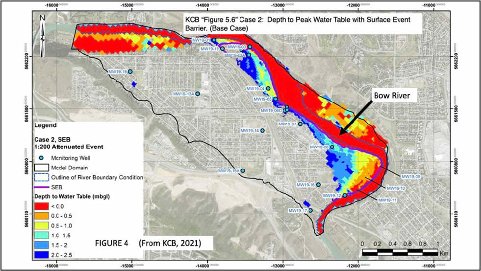
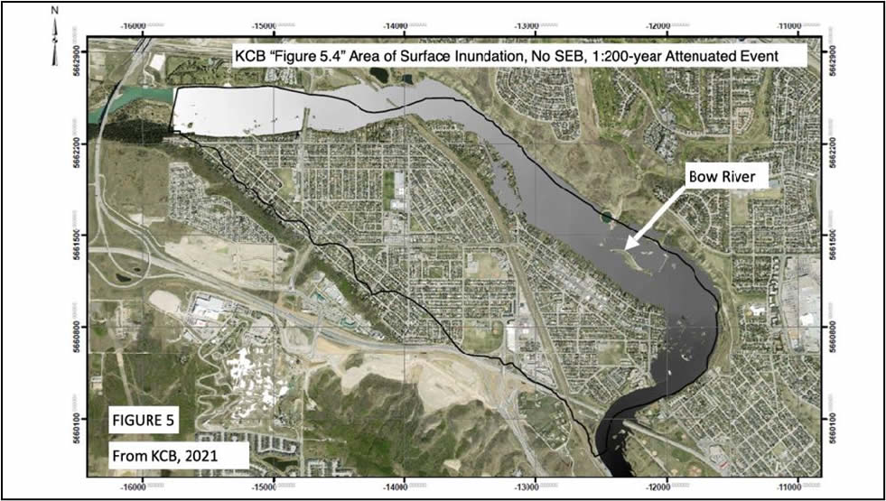
The City has further explained ‘marginally’, in their Community Information Booklet (City of Calgary, 2021) that this reduction will range from 0.0 to 0.8 metres, averaging 0.4 m, not much when you consider that most basements are approximately 2.5 m deep and that most mechanical services (e.g. furnaces, water heaters) will be destroyed by water far less than 1 m deep in the basement. The relevant KCB map in Figure 4 , shows widespread basement flooding in both East and West Bowness within the flood fringe area. It is disappointing, though not surprising, that the areal extent of overland flow without the barrier is very similar to the areal extent of groundwater flooding with the barrier (Figures 5 and 4 ).
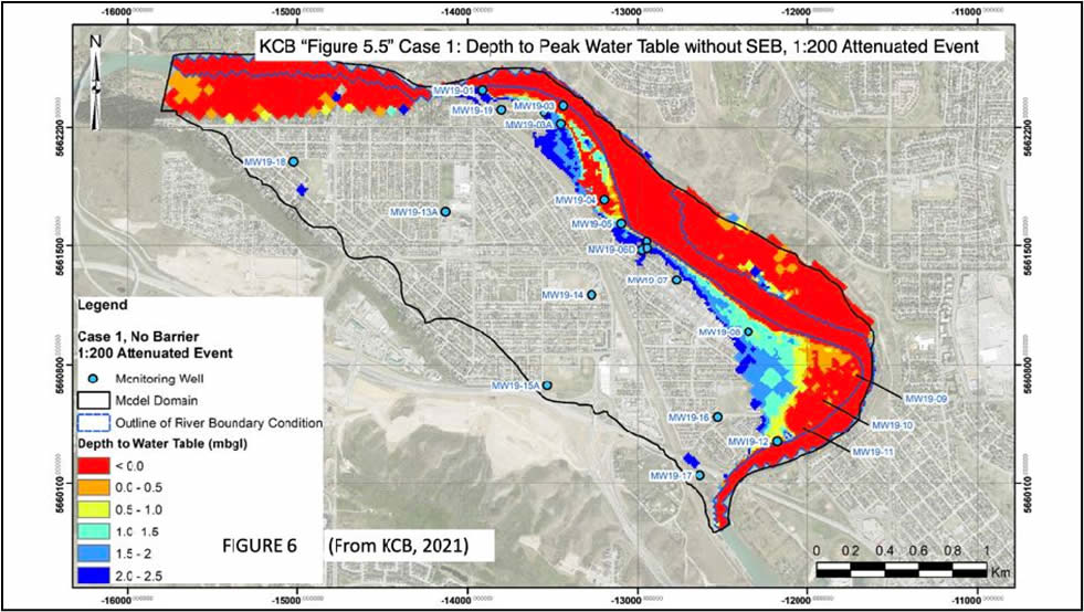
It is also noteworthy that the areal extent of basement level groundwater flooding is very similar between the no barrier and barrier cases (Figures 6 and 4) as the SEB addresses overland flooding only.
So, the result will be over a hundred houses not adjacent to the river with groundwater flooded basements even with the Surface Event Barrier in place, with basement flooding for all riverfront residents a certainty, despite the presence of the barrier in their backyards.
The U of C study concluded that the majority of flood damage financial losses were from basement flooding, a conclusion echoed by the insurance industry. Homeowners with homes having first floors above the flood elevation of the river had ONLY basement damages in 2013. Furthermore, Dr. Ryan and her students observed that the main factor in whether a homeowner was groundwater flooded was the depth of their basement, not solely their distance from the river (see Abboud et al, 2018). This is because the groundwater surface rises in sync with the river level in high permeability sediments such as those found in Bowness. The level of rise and the distance from the river for flood damages will depend upon the local permeability of sediments within the river valley, the local thicknesses of these permeable sediments, the depth of the river relative to homeowners’ basements and the amount of time that the flood conditions exist. A presentation by Dr. Ryan on this topic can be viewed at https://www.youtube.com/watch?v=I3I5PolKGlg . An excellent illustration of this problem was observed in Bowness in 2013, as some buildings hundreds of meters from the river had basement flooding (e.g. Bow Cycle, Irish Cultural Center).
All studies done for the City to date show that that the proposed Surface Event Barrier (SEB) will not solve this problem (IBI Golder, 2017; Associated Engineering; KCB, 2021). The relevant maps illustrating the degree of basement flooding expected in the community of Bowness with the barrier in place are cited in the aforementioned Section 1. See BownessBarrier.ca
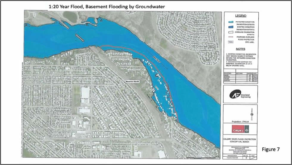
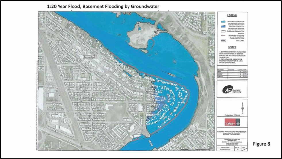
This widespread and significant groundwater damage problem was identified and mapped out both by Associated Engineering (AE) in their 2018 study (Figures 7 and 8), and by KCB in their 2021 report (Figure 4). It is noteworthy that in the City’s 2017 Alberta Community Resilience Program application for funding for the Bowness Barrier, The City stated that “However, a benefit-cost assessment that groundwater mitigation doesn’t provide enough benefit to justify the additional cost”. Funding was denied as the barrier did not meet the requirements of the program.
KCB, in their Groundwater Report, actually evaluated the engineering aspects of several groundwater mitigation schemes and noted that all of them would be technically feasible and extremely intrusive to the community (i.e. require a large surface ‘footprint’ and a lot of construction in homeowners’ yards). Owing to the significant expense involved with groundwater mitigation, and presumably the negative impact on the economics, the City has opted not to include these costs in their Triple Bottom Line (TBL) analysis going forward.
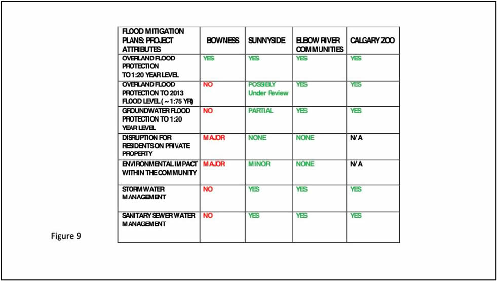
So, unlike in other river communities, The City currently has no plan to protect Bowness residents from basement flood damages or the ensuing homeowner costs, despite the fact that these damages will be a certainty with their ‘Surface Event Barrier’ (SEB) in place and utilized at its design flow rate of 1230 m3/s. For a comparison of flood community project attributes, see Figure 9.
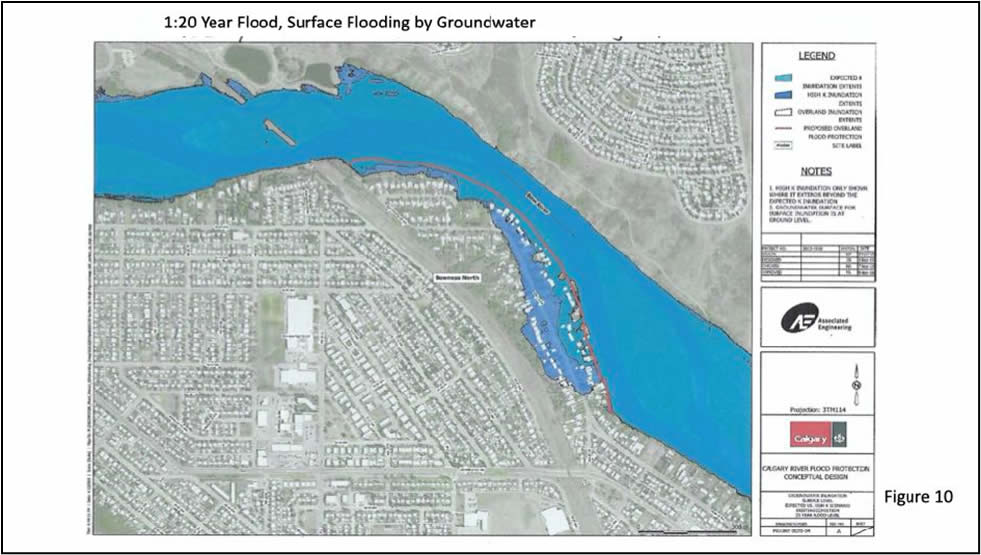
The 2018 Associated Engineering (AE) study concluded that because of the presence of thick, high permeability sand and gravel beneath Bowness (Figure 21), it is likely that the groundwater surface will rise to a level only slightly less than that of the river on the landward side of the barrier. This will occur as water moves beneath the barrier and then to surface, resulting in ‘secondary’ overland flooding despite the barrier (Figures 10 and 11). Depending on main floor elevations, this raises the possibility of main floor flood damages for a few properties in addition to the unavoidable basement flooding, especially at the barrier design flow rate of 1230 m3/s. For comparison, the 2005 flood flow rate peaked at only 791 m3/s and resulted in only localized basement and minimal localized overland flooding. Furthermore, the basement flooding which did occur on Bow Crescent in 2005 typically involved only shallow depth and therefore water influx that could be pumped. The 2021 KCB Groundwater Report has confirmed this unintended consequence of surface barrier construction, previously noted in the 2018 Associated Engineering study (Figure 4) .
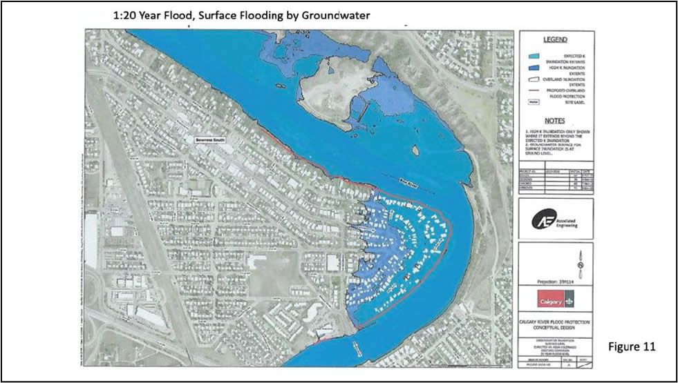
Despite this important conclusion noted by KCB, The City did not present in their Bowness Flood Barrier Feasibility Study Community Information Booklet (2021), the map (Figure 4) illustrating both the groundwater (basement) flooding and groundwater-to-surface flooding problems to the community, choosing rather to denote small areas where the ground water ‘might’ come to surface (page 9 of the booklets). It is incredible that they chose not to state the obvious here, that if ground water is at surface anywhere near your home, your basement is entirely full of water. This important mapping, contained within the 2021 KCB Groundwater Report can also be viewed at bownessbarrier.ca, where residents can zoom into the location of their home and see how deep the groundwater surface is projected to be there.
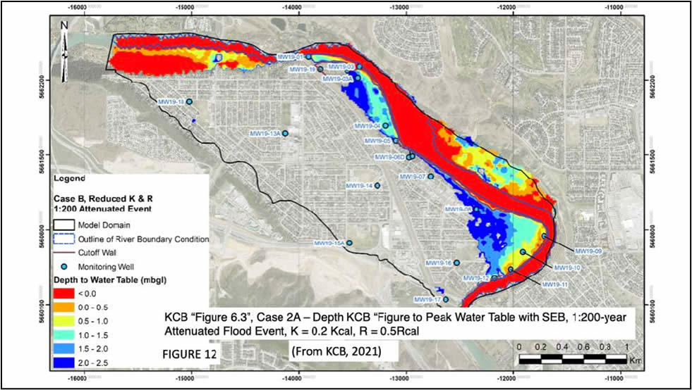
KCB ran two sensitivities for groundwater flood modelling, at 1/5 the base permeability and at 5 times the base permeability, although only the lower permeability case mapping appears in KCB’s report (Figure 12). The third-party reviewer Advisian, hired by the City to provide an unbiased appraisal of KCB’s engineering work, noted in the December 2020 “Groundwater Debrief” with the Bowness Flood Mitigation Working Group that the actual permeability could well be higher, not lower, than the base case presented in KCB mapping owing to a number of factors, not the least of which was the lack of detailed geological mapping in the area. This is a function of both the paucity and poor spatial distribution of the borehole data. It appears that the small areas of projected groundwater to surface noted in the community booklets were derived from this map (Figure 12). Utilizing a lower permeability than the ‘base case’ would present a far more optimistic picture of the expected surface damage extent with the Surface Event Barrier in place. BRFM considers the omission of the ‘base case’ groundwater flooding map (Figure 4) from the community booklets to be a misleading representation of the facts.
The technical lead for the Bowness Responsible Flood Mitigation Society constructed a bench model to illustrate the nature of this problem locally. This model, presented to the public at the 2019 ‘Tour de Bowness’ community event, clearly and simply demonstrated the relationship between various river flow rates, their effects on the groundwater surface, and the resulting probable surface flooding in Bowness even with the proposed barrier in place. A video explaining this model is available at https://youtu.be/zvF0xW_xoXE
The City’s stated objective, to be able to flow the river through Bowness at up to 1230 m3/s for an unknown period of time (perhaps up to 5 days) will result in widespread groundwater flooding, with likely groundwater rise to surface, according to the KCB Groundwater Report (Figure 4). This is of course, only true provided that the barrier is not actually overtopped, which is a significant risk as it is only a 1:20 year flood design. Considering that so many residents’ main floors are above ground level, and that the Elbow River 2013 flood study (Abboud et al, 2018) concluded that most of the damage and financial losses were related to basement flooding only, this will mean that all of the financial loss risk will in future rest with individual homeowners. Current Alberta Disaster Relief funding guidelines dictate that The Government of Alberta (GoA) will not cover flood damages caused by rising groundwater, but by overland flooding only. It is also typical that insurance companies cover only sewer backup, and deny coverage of any basement damages caused by rising groundwater, leaving homeowners to cover all flood costs themselves.
The majority of the damage, and the production of ‘years‘ of refuse going into landfills within the space of one month in 2013 resulted from the destruction of peoples’ basements within the flood fringe area. The City of Calgary chose to be generous in 2013, and covered all the costs of moving this massive amount of material to the landfills. If they refuse to do so for future floods, then this will be yet another cost which to be borne by individual homeowners.
The City concedes that the barrier is intended to be ‘complementary’ to the presence of ‘upstream mitigation’ (i.e. a dam on the Bow River upstream of Calgary). The GoA is at present assessing 3 potential sites for such a structure, whose completion date is at present estimated to be over a decade away. There is also the unsettling possibility that it will never be built. A barrier without this upstream mitigation in place could be worse from a potential damage standpoint for Bowness residents for the following reasons:
- The 2005 and 2013 floods illustrated the importance of natural vegetative baffling by trees and shrubs in back yards along Bow Crescent by limiting dangerous flow rates, property damage and river bank erosion. The proposed barrier will remove hundreds of mature trees and shrubs with the future requirement for no vegetation rooted within the barrier. Depending on the location of the barrier on individual properties relative to the river, it is conceivable that this removal of vegetation would result in increased erosion and physical property loss during the next flood. If this was an identifiable risk pre-construction, it could expose The City to future litigation by affected property owners.
- Without the presence of additional upstream mitigation there is a much higher probability that the barrier will be overtopped during the any given flood owing to the sheer size of individual flood events in the historical record. Past flood data for both the Bow River and the adjacent Oldman River basins shows extreme bi-modality, with a tendency of long periods with very low, occasionally verging on drought level, flow rates, where no barriers were required (Figures 13 and 14), punctuated by flood events with flow rates many times higher. For a more complete data set, prorating flow rates on the Oldman at 0.50 for the basin area ratio of 0.50 for comparison purposes. Flood events on the Bow having mid-range flow rates between 800 and 1200 m3/s are rare in the flood record, and climate change is most likely to lead to larger, not more mid-range flood events, and potentially more severe droughts. So, it would appear that The City is planning the installation of infrastructure whose design rate range is the least likely to be required based on the historical data.

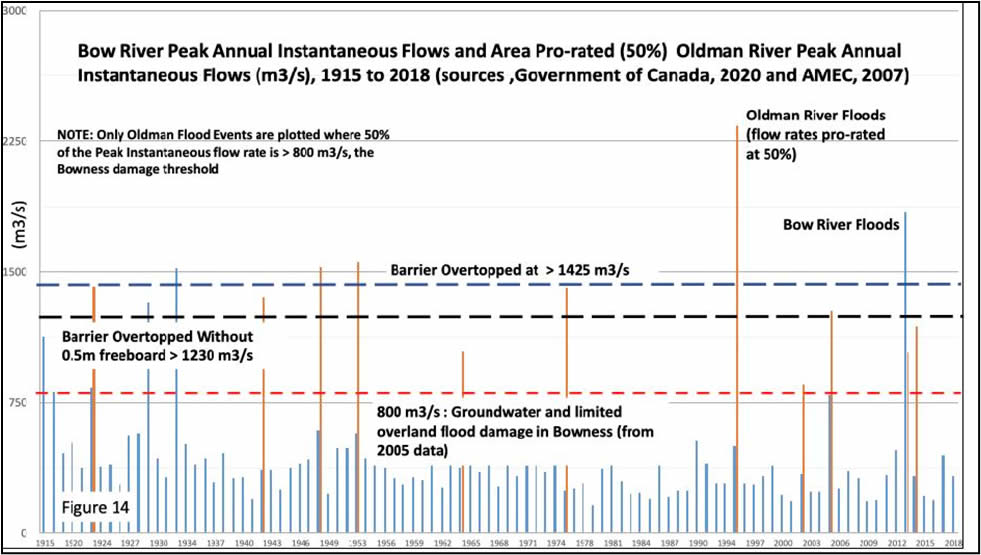
Another recurring optics issue is that, while The City frequently mentions the 2013 flood (e.g. page 1 of the recent Community Information Booklet) in any barrier discussion, they invariably fail to note that another 2013 volume flood (approximately a 1:75 year event) would overtop the planned barrier, even with the current TransAlta Operating Agreement in place. This causes additional challenges as it would mean large volumes of contaminated water trapped behind the barrier which would have to be returned to the river somehow, with the attendant costs.
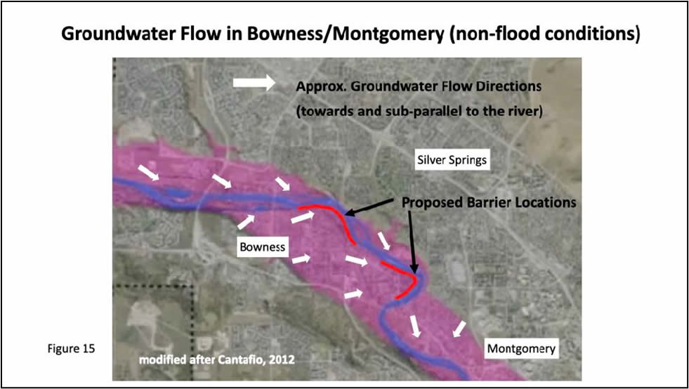
KCB’s comprehensive Groundwater Report, presented to the Bowness Flood Barrier Community Working Group in December 2020, confirmed the 3-dimensional nature of groundwater movement beneath the community of Bowness. Groundwater moves through the entire river valley all year long, discharging to the river during certain months, especially during fall and winter, with river water movement into the valley sands and gravels beneath the community, especially in spring and summer) (Figures 15, 16 and 17). The water which we see in the river actually represents the lowest level of the groundwater at any given point along the river. When the river rises in spring and/or during a flood, water moves into the river valley sediments at all points along the river, not just where one might try to intercept it with a barrier (Figures 16 and 17). So, the groundwater surface is able to rise even where a surface event barrier exists as water enters the area from all points along the river up-gradient not impeded by a barrier, not just perpendicular to the river and beneath a surface event barrier. In west Bowness, under high water conditions (June 2019 data), KCB’s mapping shows the groundwater beneath West Bowness along Bow Crescent moving parallel to the river, while in East Bowness it moves almost North to South beneath the community.
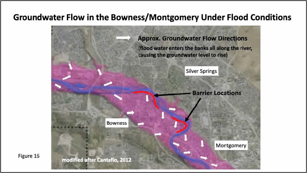
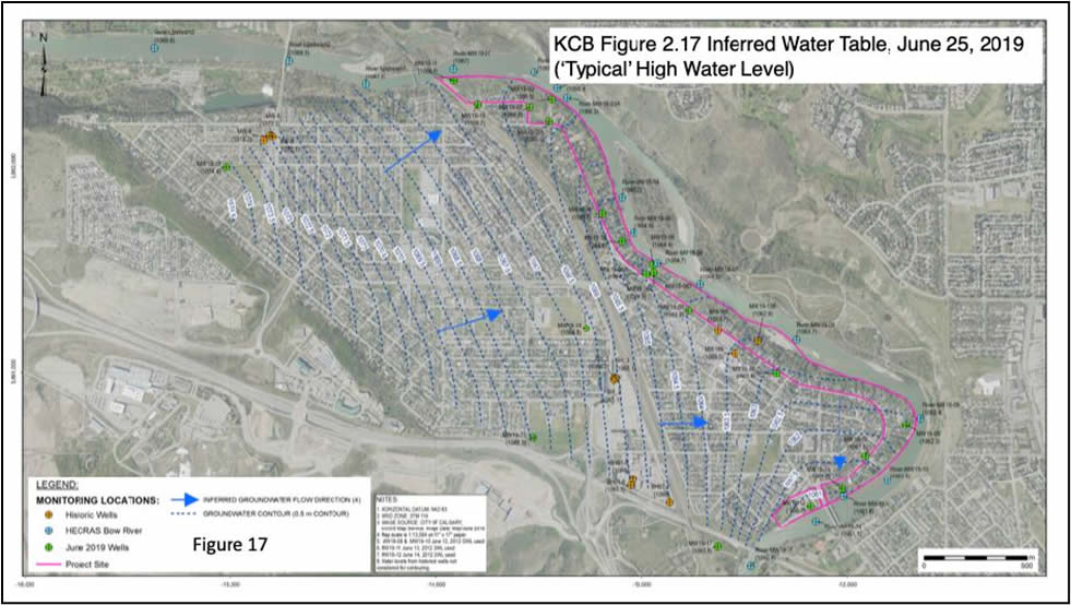
KCB’s detailed hydrogeological and geochemical work provided an excellent illustration of both the direction and magnitude of groundwater movement beneath the community at various times during the year. It also clearly showed that groundwater flooding within the community will be in enormous problem (e.g. Figure 4) during future floods, even with the Surface Event Barrier in place.
It is becoming apparent to BRFM that The City considers groundwater flooding to be each individual homeowners’ problem, not the City’s, even if they cause it.
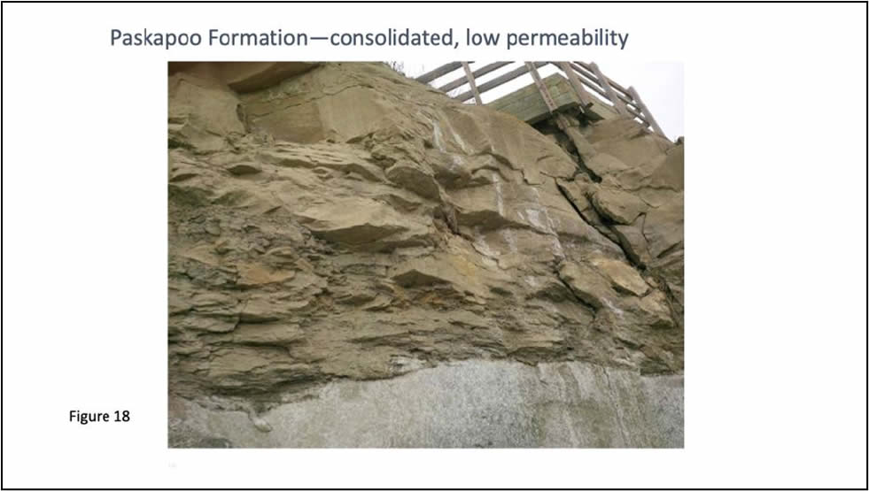
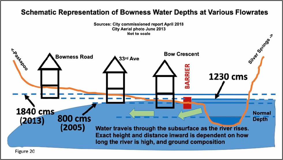
The barrier’s impermeable core will not be seated in unweathered, relatively low permeability Paskapoo Formation siltstone or sandstone (Figure 18), but rather within the widespread sand and gravel deposits (Figure 21), allowing easy water movement from the rising river underneath it to raise the groundwater surface landward of the barrier (Figures 19 and 20). This problem exists because the permeable sand and gravel along the river in Bowness (e.g. Figure 21) is much thicker than the approximately 2 meter projected depth of the barrier. Seating the barrier in the less permeable bedrock between 5 and 20 meters below ground, as assessed by KCB in 2021, would be both extremely expensive and intrusive, and would still not address the aforementioned 3-D groundwater flow problem.
The unfortunate fact is that even if The City were able to completely isolate the groundwater table from the river along its length to prevent flood waters from entering and elevating it, the groundwater, which is entering the river at all times of the year except during those periods of elevated river flow, would be effectively “dammed” behind the barrier, flooding the neighbourhood, especially during high intensity rainfall or snow melt events.
This problem was confirmed and mapped out by KCB in their 2021 Groundwater Report, and constituted one of several groundwater mitigation scenarios that they evaluated and presented to The City and the Bowness Flood Barrier Community Working Group. In Appendix V of the 2021 Groundwater Report, on page V-7, KCB stated that:
“Figure V-1.4 presents the peak groundwater level period observed in 2019 (June 25) and shows that under normal flow conditions, the groundwater cut-off wall results in a water level rise in the southeast, due to the ‘damming’ effect of the wall which does not allow as much groundwater to discharge to the Bow River. This effect is worse when the barrier is extended to the top of competent bedrock (Figure V-1.5).”
KCB modelled numerous technical cases for groundwater flooding mitigation in Bowness, outlined in Appendix V, but concluded that all would be extremely intrusive to the community and as such, The City is not considering any form of groundwater mitigation for Bowness.
A curious demonstration of this groundwater damming phenomenon already occurs in at least one home near the river in Bowness, where the resident’s sump pump only runs in the winter (excepting flood periods of course). This locally elevated groundwater situation is believed to result from the shallow level ‘damming’ of the effluent groundwater flow by ice at and beneath the sediments at the bank edge during very cold periods.
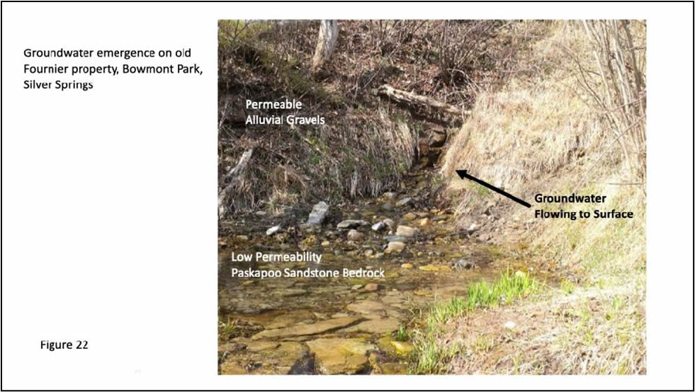
Year-round groundwater flow into the river from springs in the valley wall can be easily observed both in “Waterfall Valley” and on the old Fournier property, both within Bowmont Park south of Silver Springs (Figure 22).
What about sump pumps? Many residents on both the Bow and Elbow rivers have these in their basements. Unfortunately, the Elbow Park resident surveys conducted by the University of Calgary (Abboud et al, 2018) after the 2013 flood showed that the groundwater frequently entered the sumps first, which makes sense as they are situated at the lowest point in the basement and are typically connected to weeping tiles (perforated pipes) located around the foundation. A further problem is that the amount of groundwater which will enter a basement is so large in high permeability alluvial soils that no pump will be able to effectively displace it (see below).
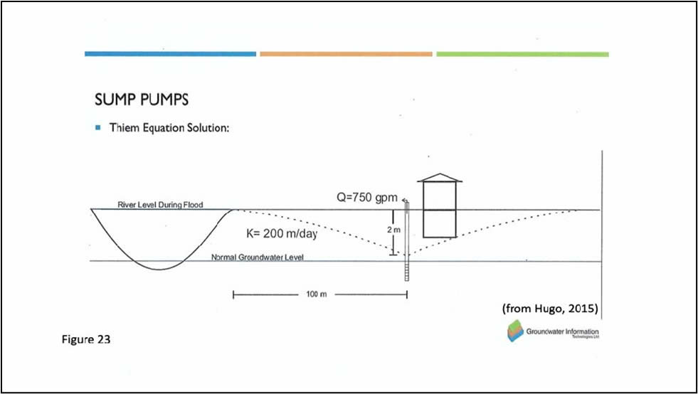
An example calculation is provided in the presentation by Hugo (Figure 23), which illustrates that a homeowner would have to pump 750 gallons (3.4 m3) per minute to keep the water level 2 metres below ground level (and therefore close to below their basement). A one horsepower pump will move only about 110 gallons (0.5 m3) per minute, assuming the homeowner had not had their power cut off during a flood by The City, which is a likely occurrence for safety reasons.
In their 2021 Community Information Booklet, The City suggests that homeowners install sump pumps to self-mitigate groundwater flooding, yet provide no information as to what degree of pumping capacity would be required. Based upon the soil permeability values that were measured in boreholes in the 2021 KCB study, this pump capacity would be very large indeed, and likely beyond most homeowner’s financial resources.
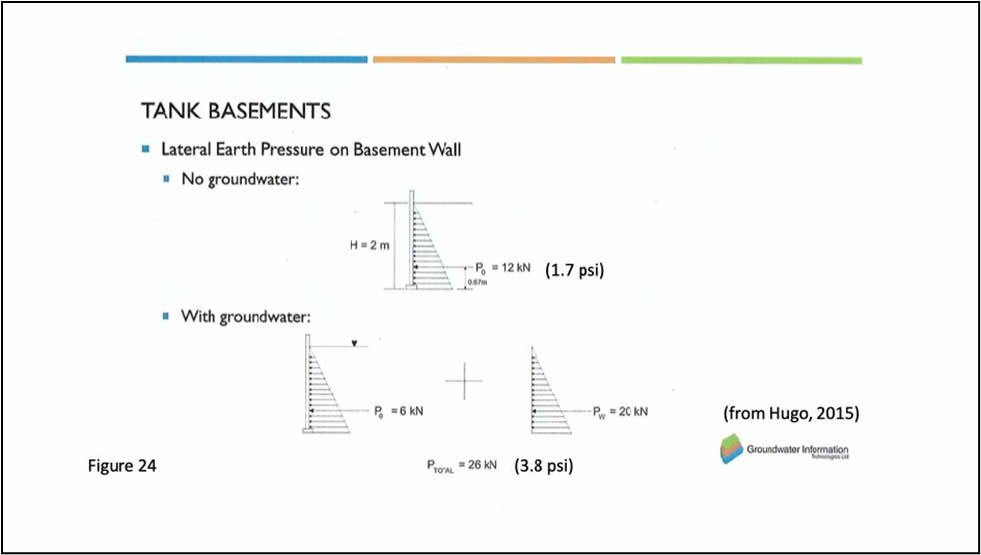
An additional problem arises; even if this pumping capacity was to be available and employed, a 2 meter (6.6 feet) water column against a foundation can be calculated to exert an additional force of 20 kN (2.9 lb/in2) upon it (Figure 24). More importantly perhaps, a 6 inch (15.2 cm) thick section basement floor weighs only 2.4 times as much as the same thickness of water (assuming a cement density of 2.4 g/cm3). It therefore only takes a 15 inch water column around the foundation and beneath the floor to exceed the weight of this concrete. As the water deepens, the result can be the lifting and cracking of the basement floor, assuming the homeowner was actually able to pump all of the water out of the basement during a flood.
This significant damage issue was actually observed in a home in the 6700 block of Bow Crescent in 2013, where the homeowner had access to industrial-grade pumping capacity but had to cease pumping owing to the ensuing lifting and cracking of the basement floor. The end result was that the basement had to be allowed to fill with groundwater to prevent further damage.
Unfortunately, all of the data suggest that a homeowner must simply allow their basement to fill with groundwater to avoid structural damage to their walls and basement floors, unless perhaps the water around the foundation is considerably less than 1 metre deep. This of course means destroyed basement development, including mechanical features such as furnaces and water heaters. And as noted above, if water is pooled at surface anywhere in the immediate neighbourhood then all nearby basements will be full to ground level with water. This, because in high permeability sediments the water table will have a very shallow slope, as shown in the relevant KCB Groundwater Elevation maps (e.g. Figure 17, where the slope near the river ranges from only 2 to 4 metres per kilometre).
As has been discussed, the major flaw with The City’s plan for a barrier in Bowness pertains to the fact that groundwater levels will rise on the landward side in concert with the rising river, flooding resident’s homes, initially via basement flooding and then potentially secondarily by overland flooding in the lowest lying areas. One of the methods by which this will occur is through the stormwater, and to a lesser extent, the sanitary sewer system. Both systems are decades old in Bowness, increasing the likelihood that they are no longer completely sealed and therefore exposed to groundwater inflows under flood conditions.
This is particularly true for the concrete segments of the stormwater system, which are not really required to be as completely sealed. In fact, certain geochemical anomalies noted within groundwater samples elicited the suggestion from KCB, and echoed by the third party reviewer, Advisian, that they could be reflective of groundwater recharge in part from an unsealed stormwater system nearby. This matter was discussed in the “Groundwater Debrief” meeting with the Bow River Flood Barrier Community Working Group on December 7, 2021.
Both stormwater and sanitary pipe systems are typically laid in non-compressible, and therefore, unfortunately, permeable sands and gravels, to minimize the potential for uneven settling and/or breakage over time. The stormwater system empties directly into the river and The City therefore plans to install gates at the river outflows to prevent water entering the pipes directly during floods. This will not be entirely effective however as the water will enter the permeable soil in which the pipes are laid and then likely find its way into storm drains and manholes through openings in pipe joints, flooding the streets more easily than in the absence of this necessary pipe system. In fact, rising groundwater will typically find its way into these pipes everywhere along the streets. This was observed in Sunnyside in 2013, along with additional ‘upslope’ stormwater system issues which The City plans to address in Sunnyside. Unlike Sunnyside however, there is no plan for any type of stormwater management (i.e. large volume pumping) during any future flood in Bowness.
In 2020, The City made a presentation to the Bowness Flood Barrier Community Working Group, of which BRFM is a member, on stormwater handling in the community should the planned stormwater gates be necessarily closed during a flooding event coincident with a significant rainfall event. The presented maps showed water pooling at surface at the west end of Bow Crescent up to 0.5 metres deep, rendering it impassable. Inexplicably, The City uses only a 1:5 year rainfall event volume as an input parameter for flood and storm water modelling, despite the fact that the barrier design entails a 1:20 year flood event. Since individual floods are invariably the result of excessive rainfall, why the disconnect between the rainfall probability and the flood probability volumes? Obviously utilizing a smaller rainfall event presents a more optimistic picture of the potential for surface water pooling during rainfall event coincident with a flood event. The final version of the Stormwater Report is due out early in 2021.
Extensive groundwater flooding in all dwellings whose basement floors are lower than the approximate elevation of the river during a flood event, precipitated by a rising groundwater table, means that the local sanitary system will be unusable by both flood-affected residents and those situated upslope who may have neither overland nor basement flooding. This latter condition was observed on Bow Crescent during the 2013 flood where upslope Bow Village Crescent residents were unable to use their sanitary sewer systems despite not having been flooded. Despite this obvious groundwater-induced problem, The City has suggested that residents can remain in their basement-flooded homes safely. This despite the likelihood that city services such as sanitary sewer, water and power, would be shut off in the community. To suggest that residents would not be inclined to evacuate under these conditions is unrealistic.
It is evident from the aforementioned discussion that flooding in Bowness will occur anytime that the river level rises above the level of residents’ basements (Figure 20). It was concluded in the Flood Mitigation Measures Assessment (FMMA, 2016) study for the Elbow River that the only way to save residents from all forms of flood damage is through the construction of upstream mitigation in the form of the proposed Springbank Off-stream Reservoir (SR-1) and the recently completed Glenmore Reservoir gate improvements.
Flood communities on the Bow River should be offered the same protection. On the Bow River, some progress has been made on upstream mitigation in the form of the GoA’s agreement with TransAlta for control of water levels in the Ghost Reservoir (the “TA Agreement”). The flood of 2005 provided valuable information as to at what flow rate flood damage begins to occur in Bowness (just under 800 m³/s). The only way that flow through Bowness can be kept below this level is by intercepting enough of the water upstream, through the presence of a dam of sufficient size to temporarily store at least the volume of water required to mitigate a 1:100 year flood event.
The bottom line is that without sufficient upstream interception and storage, residents whose basements were flooded in 2005 and/or 2013 (and some main floors, depending on floor elevations) are projected to be flooded again anytime the river flow rate through Bowness exceeds 800 m3/s, even with the Surface Event Barrier in place. In other words, every time The City, in consultation with TransAlta, deems it acceptable to flow the river at any rate in excess of 800 m3/s, up to the barrier’s design flow rate of 1230 m3/s, a large portion of Bowness will be groundwater flooded.
Conclusions
In 2021, The City completed hydrogeological (groundwater), geophysical and geochemical investigations in the Bowness community to obtain data on alluvial sediment thicknesses, compositions and distribution, as well as groundwater flow directions and sources. BRFM commends the City for completing the studies. The study results are critical before a decision is made as to whether or not a barrier would be effective in protecting residents from future flood damage losses, be they physical or financial. The results of all of these studies have now been presented to the Bowness Community Flood Mitigation Working Group, with the possible exception of the final Stormwater study which is being conducted by The City itself and due to be completed early in 2021.
After reviewing the long-awaited studies conducted by The City and in consultation with 3rd party experts, BRFM maintains its original position that with the proposed surface event barrier Bowness residents who live adjacent to the river or nearby will experience costly flood damages from groundwater.
It is apparent from the tone and content of the Community Information Booklet that were delivered in January 2021, that The City is reluctant to admit that they are only concerned with overland flooding, while recognizing that widespread groundwater flooding will occur in the neighbourhood with the barrier in place. It appears, The City is not considering in the barrier decision, the extensive damage and financial losses that will be incurred by Bowness residents.
Lastly, upstream flood mitigation, designed to limit flow through Bowness to less than 800 m3/s, should be the sole focus of The City’s efforts at this time through cooperation with the GoA. Their focus should not be a technically flawed surface event flood barrier that will be environmentally destructive, cost an estimated $35 million and a demonstrably ineffective waste of taxpayers’ dollars. The imperative continuation of the TransAlta Operating Agreement by The GoA affords the Bowness community significant protection from both groundwater and overland flooding for up to about a 1:30 year flood event. Other communities are being offered effective protection from both overland and groundwater flood damages up to at least a 1:100 year event, and the residents of Bowness should be provided the same consideration through the construction of sufficient upstream mitigation to achieve this.
References Cited
Abboud JM, Ryan MC, Osborn GD. (2018) Groundwater flooding in a river connected alluvial aquifer. J Flood Risk Management.
2018; 11:e12334. https://doi.org/10.1111/jfr3.12334
AMEC Earth & Environmental (2007), Calgary, City of Lethbridge Flood Risk Mapping Study Report
Associated Engineering (2018), Permanent Flood Barrier Protection Assessment, report for the City of Calgary p:\20133936\00_flood_protect_cd\engineering\03.02_conceptual_feasibility_master_plan_report\20161012_finalreport\final\rpt_cgy_river_flood_final_2018-04-26.docx
Cantafio, L. (2012), Groundwater-surface water interaction, non-point source chloride loading, and flow generation along an urban river, M.S. thesis, 164pp., Univ. of Cal. at Calgary, Alberta. September.
City of Calgary. (2016). Flood Mitigation Measures Assessment. Calgary: City of Calgary.
City of Calgary. (2021). Bowness Flood Barrier: Feasibility Study, Community Information Booklet (distributed in January, 2021).
Government of Canada, Environment and Natural Resources; https://wateroffice.ec.gc.ca/search/historical_e.html
Hugo, K. (2015). Bow river floods and groundwater. Water Technologies Symposium, Alberta, Canada: Kananaskis.
IBI Group/Golder Associates Report (2017). Flood Mitigation Options Assessment-Phase 1. Prepared for the City of Calgary
Klohn Crippen Berger (January, 2021). CoC Bowness Flood Control Barriers, Hydrogeological Characterization and Groundwater Flow Modelling Report, prepared for The City of Calgary
Klohn Crippen Berger, 2021, Hydrogeological Characterization and Groundwater Flow Modelling, 201103DR Bowness Numerical Model, APPENDIX V, Numerical Groundwater Model – Groundwater Flood Mitigation Simulations
Ryan, Cathy (2014). The Role of Groundwater in Flooding. Canadian Water Resources Association’s (Alberta Chapter) conference on the 2013 Alberta Floods, The Rains, Response, Recovery & Resiliency, March 23-25, 2014 in Calgary, Alberta. https://www.youtube.com/watch?v=I3I5PolKGlg


